
Mass Movement Risk Assesment as the Basis for Disaster Mitigation at Petirtaan Belahan Site in Pasuruan Region Penilaian Risiko Gerakan Tanah sebagai Dasar Mitigasi Bencana di Situs Petirtaan Belahan Kabupaten Pasuruan
Article Sidebar
Main Article Content
Abstract
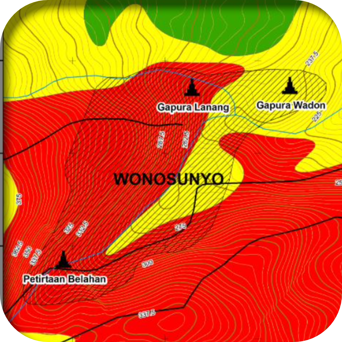
The Petirtaan Belahan Site area, located in Pasuruan Regency, East Java, is a designated cultural heritage site. Such sites are finite in number, unique, and non-renewable, thus highly vulnerable to damage which makes protecting them from the threat of disasters risk essential. This research explores on how to assess disaster risk in the Petirtaan Belahan Site area and what mitigation efforts can be undertaken. A qualitative research approach was used with data collected through field observations, map document studies, interviews, and literature reviews. The data used include Cunggrang Inscription, Kakawin Negarakertagama, environmental condition maps, scientific literature, and interview results. Findings shows that the site holds significant importance for history, education, economy, and religion, thus its existence must be preserved. The site faces low to moderate hazards, primarily triggered by rainfall conditions and land use changes. Vulnerability linked to the structures and the absence of adequate reinforcement systems, while disaster preparedness capacity has not been optimized. To address these risks, disaster mitigation efforts can be implemented through slope reinforcement with soil conservation, land management, provision of preparedness facilities, and community involvement in education and disaster response teams.
Article Details

This work is licensed under a Creative Commons Attribution-NonCommercial-ShareAlike 4.0 International License.
References
Arda, F., Ghautama, G., Wijayanto, P., Mutmainnah, L. S., & Widiastomo, Y. (2018). Cagar Budaya Tangguh Bencana. Kementerian Pendidikan, Kebudayaan, Riset dan Teknologi.
Badan Penanggulangan Bencana Nasional. (2021). Pengkajian Risiko Bencana Partisipatif.
BPCB. (2019). Fasilitasi Pelestarian Cagar Budaya Petirtaan Belahan Pasuruan.
Fitri, R. F. (2018). Simbol Bangunan pada Komplek Gapura, Masjid, dan Makam Sendang Duwur Kecamatan Paciran, Kabupaten Lamongan, Jawa Timur. Jurnal Antropologi.
Flantis, D. (2020). Morfologi dan Klasifikasi Tanah. Lembaga Pengembangan Teknologi Informasidan Komunikasi (LPTIK) Universitas Andalas.
Freimon, J. (2022). Arrangement of the Petirtaan Temple Belahan Area as an Effort to Preserve Cultural Heritage to Support Preparation Towards a Tourism Village in Wonosunyo Village, Gempol District, Pasuruan Regency 2009-2022. 2, 2–3.
Henderson, J., & Lingle, A. M. (2018). Preventive Conservation in Archaeological Sites. In The Encyclopedia of Archaeological Sciences (pp. 1–4). Wiley. https://doi.org/10.1002/9781119188230.saseas0476
Herwindo, R. P., & Wibawa, F. (2015). Kajian Arsitektur Percandian Petirtaan di Jawa (identifikasi). 16–77.
Krisnandi, R., Trianda, O., Rizqi, A. H., Febby, L., & Hanafi, M. N. (2021). Identifikasi Kawasan Rawan Bencana Longsor Metode Skoring Daerah Mojotengah Dan Sekitarnya, Kecamatan Reban, Kabupaten Batang, Provinsi Jawa Tengah. Prosiding Nasional Rekayasa Teknologi Industri Dan Informasi XVI Tahun 2021 (ReTII), 501–508.
Kusuma, T. A. B. N., & Damai, A. H. (2021). Disaster Mitigation of Masjid Raya Sultan Riau Site and Its Conservation. Prosiding Balai Arkeologi Jawa Barat, July, 333–344. https://doi.org/https://doi.org/10.24164/prosiding.v4i1.29
Noor, J. (2012). Pengantar Geologi. Universitas Pakuan.
Noto, A. (2022). Kerja Bhakti Bersihkan Musola dari Longsoran di Situs Sumber Tetek. TVDesa. https://tvdesanews.id/musala-di-situs-sumber-tetek-tertimpah-longsor/
Pratikno, H., Rahmat, H. K., Hadi, S., Program, S., Magister, S., Bencana, M., & Nasional, K. (2020). IMPLEMENTASI CULTURAL RESOURCE MANAGEMENT DALAM MITIGASI BENCANA PADA CAGAR BUDAYA DI INDONESIA 1. NUSANTARA : Jurnal Ilmu Pengetahuan Sosial, Vol 7, No(c), 1–11.
Puslittanak. (2004). Laporan Akhir Pengkajian Potensi Bencana Kekeringan, Banjir dan Longsor di Kawasan Satuan Wilayah Sungai Citarum Ciliwung, Jawa Barat Bagian Barat Berbasis Sistem Informasi Geografi. Pusat Penelitian dan Pengembangan Tanah dan Agroklimat.
Rahardjo, S. (2021). Mengelola Cagar Budaya di Wilayah Rawan Bencana Sudah Siapkah Indonesia? Berkala Arkeologi, 283–303.
Resink, Th. A. (1968). Belahan or Myth Dispelled, Indonesia.
Rois, M. (2021). Hujan Deras sebabkan Banjir dan Longsor di Gempol. Pantura7.Com. https://www.pantura7.com/2021/01/05/hujan-deras-sebabkan-banjir-dan-longsor-di-gempol/
Saktiani, D., Widya, K., Aminullah, Z. P., Marginingrum, N., & Septi, N. (2019). Kakawin Nagarakertagama Teks dan Terjemahan. NARASI.
Subagyono, K., Marwanto, S., & Kurnia, U. (2013). Teknik Konservasi Tanah. Balai Penelitian Tanah.
Tanudirjo, D. A. (2004). Penetapan Nilai Penting dalam Pengelolaan Benda Cagar Budaya. 26–28.
Pemerintah Republik Indonesia. (2010). Undang-Undang Nomor 11 Tahun 2010 tentang Cagar Budaya (Lembaran Negara Republik Indonesia Tahun 2010 Nomor 130).
Utama, H. F., & Subekti, A. (2023). ANALISIS FUNGSIONAL TERHADAP KEBIJAKAN PEMERINTAHAN PU SINDOK PADA ABAD KE-10 M. 12(148), 83–102.
Warta Bromo. (2021). Di Gempol, Banjir dan Longsor Landa Dua Desa. Warta Bromo. https://www.wartabromo.com/2021/01/05/di-gempol-banjir-dan-longsor-landa-dua-desa/
Widiah, S., & Kasdi, A. (2018). Historical Study of the Cunggrang Inscription as a Historical Source during the Period of Mpu Sindok 929-947 AD. In Journal Pendidikan Sejarah (Vol. 6, Issue 1).
Zuidam, R. A. Van. (1985). Aerial Photo – Interpretation Intrain Analysis and Geomorphology Mapping. Smith Publisher.