
Groundwater Potential Assessment in the Semarang-Demak Basin Using Geospatial and Multi-Criteria Analysis
DOI:
https://doi.org/10.55981/limnotek.2025.8066Keywords:
Analytical Hierarchy Process (AHP), Geospatial Approach, Groundwater, Groundwater Potential Zone, Multi-Criteria ApproachAbstract
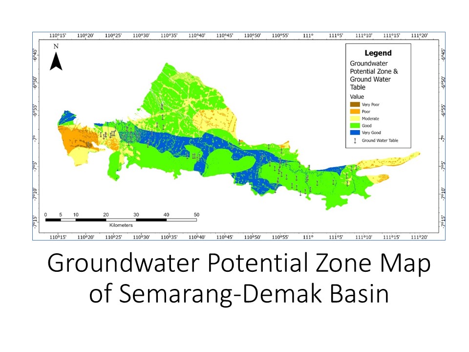
Groundwater is a critical resource for meeting the increasing demands of urban, agricultural, and industrial sectors. However, overexploitation and contamination pose significant threats to its sustainability. This study aims to assess the groundwater potential zones (GWPZ) within the Semarang-Demak Groundwater Basin, a rapidly urbanizing region in Central Java, Indonesia, where clean water availability faces mounting challenges. A geospatial approach integrating Geographic Information Systems (GIS), Remote Sensing (RS), and the Analytical Hierarchy Process (AHP) was employed to identify and classify GWPZ. Key factors analyzed include geology, lithology, slope, soil type, drainage density, rainfall, geomorphology, and land use/land cover. The results delineate the basin into five classes of groundwater potential zones, ranging from very poor to very good, offering actionable insights into areas optimal for groundwater recharge and extraction. Validation using groundwater table measurements from 71 infiltration wells confirmed a significant correlation between predicted zones and observed water levels. The results showed that zones with very high groundwater potential are concentrated in the central part of the basin, primarily due to favorable conditions such as high rainfall, alluvial formations, and low drainage density. These findings provide actionable insights for stakeholders to implement targeted groundwater management strategies, ensuring sustainable water resource utilization in the face of growing urbanization and environmental pressures.
References
Achu AL, Thomas J, Reghunath R. 2020. Multi-criteria decision analysis for delineation of groundwater potential zones in a tropical river basin using remote sensing, GIS and analytical hierarchy process (AHP). Groundwater for Sustainable Development 10: 100365.
Ahirwar R, Malik MS, Ahirwar S, Shukla JP. 2021. Groundwater potential zone mapping of Hoshangabad and Budhni industrial area, Madhya Pradesh, India. Groundwater for Sustainable Development 14(June): 100631. DOI: 10.1016/j.gsd.2021.100631
Alabdulkreem E, Alruwais N, Mahgoub H, Dutta AK, Khalid M, Marzouk R, Motwakel A, Drar S. 2023. Sustainable groundwater management using stacked LSTM with deep neural network. Urban Climate 49(March): 101469. DOI: 10.1016/j.uclim.2023.101469
Ardaneswari TA, Yulianto T, Putranto TT. 2016. Analisis intrusi air laut menggunakan data resistivitas dan geokimia airtanah di dataran aluvial kota Semarang. Youngster Physics Journal 5(4): 335–350.
Ardiyanto R, Supriatna, Indra TL, Manesa MDM. 2022. Geospatial approach to accessibility of referral hospitals using geometric network analysts and spatial distribution models of Covid-19 spread cases based on GIS in Bekasi City, West Java. Indonesian Journal of Geography 54(2). DOI: 10.22146/ijg.66099
Arulbalaji P, Padmalal D, Sreelash K. 2019. GIS and AHP techniques based delineation of groundwater potential zones: A case study from Southern Western Ghats, India. Scientific Reports 9(1). DOI: 10.1038/s41598-019-38567-x
BPS Provinsi Jawa Tengah IKSPJT. 2019. Jawa Tengah Dalam Angka. Provinsi Jawa Tengah Dalam Angka 2019.
Danso SY, Ma Y. 2023. Geospatial techniques for groundwater potential zones delineation in a coastal municipality, Ghana. The Egyptian Journal of Remote Sensing and Space Science 26(1): 75–84. DOI: 10.1016/j.ejrs.2022.12.004
Darwis H, Sc M. 2018. Pengelolaan Air Tanah. Yogyakarta: Pena Indis.
Fakhrudin M, Daruati D. 2017. Zonasi resapan air hujan sebagai dasar konservasi sumber daya air DAS Cimanuk. LIMNOTEK - Perairan Darat Tropis di Indonesia 24(1).
Gleeson T, Cuthbert M, Ferguson G, Perrone D. 2020. Global groundwater sustainability, resources, and systems in the Anthropocene. Annual Review of Earth and Planetary Sciences 48: 431–463. DOI: 10.1146/annurev-earth-071719-055251
Jia X, Hou D, Wang L, O’Connor D, Luo J. 2020. The development of groundwater research in the past 40 years: A burgeoning trend in groundwater depletion and sustainable management. Journal of Hydrology 587(April): 125006. DOI: 10.1016/j.jhydrol.2020.125006
Karra K, Kontgis C, Statman-Weil Z, Mazzariello JC, Mathis M, Brumby SP. 2021. Global land use/land cover with Sentinel 2 and deep learning. 2021 IEEE International Geoscience and Remote Sensing Symposium (IGARSS): 4704–4707.
Kawara AQ, Elsebaie IH, Alnahit AO. 2024. Groundwater recharge potential zone modeling in the Wadi Al-Lith Basin, Saudi Arabia. Applied Water Science 14(6): 117.
Kurnianto FA. 2019. Keberagaman bentuk lahan di wilayah pesisir dan kaitannya dengan karakteristik proses geomorfologi. Majalah Pembelajaran Geografi 2(2): 197–209.
Kurniawan H, Khamid A, Apriliano DD, Diantoro W. 2023. Evaluasi dan rencana pengembangan sistem drainase di Kota Tegal (studi kasus di Kecamatan Tegal Barat). Era Sains: Jurnal Penelitian Sains, Keteknikan dan Informatika 1(2): 1–11.
Lo W, Purnomo SN, Dewanto BG, Sarah D, Sumiyanto. 2022. Integration of numerical models and InSAR techniques to assess land subsidence due to excessive groundwater abstraction in the coastal and lowland regions of Semarang City. Water 14(2): 201.
Lo W, Purnomo SN, Sarah D, Aghnia S, Hardini P. 2021. Groundwater modelling in urban development to achieve sustainability of groundwater resources: A case study of Semarang City, Indonesia. Water 13(10): 1395.
Olago DO. 2019. Constraints and solutions for groundwater development, supply and governance in urban areas in Kenya.
Pande CB, Moharir KN, Panneerselvam B, Singh SK, Elbeltagi A, Pham QB, Varade AM, Rajesh J. 2021. Delineation of groundwater potential zones for sustainable development and planning using analytical hierarchy process (AHP) and MIF techniques. Applied Water Science 11(12): 1–20. DOI: 10.1007/s13201-021-01522-1
Pertiwi N. 2017. Implementasi sustainable development di Indonesia. Global Research and Consulting Institute (GlobalRCI).
Pratama IA, Sukmono A, Firdaus HS. 2018. Identifikasi potensi air tanah berbasis pengindraan jauh dan sistem informasi geografis (studi kasus: Kabupaten Kendal). Jurnal Geodesi Undip 7(4): 55–65.
Rahmati O, Nazari Samani A, Mahdavi M, Pourghasemi HR, Zeinivand H. 2015. Groundwater potential mapping at Kurdistan region of Iran using analytic hierarchy process and GIS. Arabian Journal of Geosciences 8: 7059–7071.
Ramu MB. 2014. Identification of ground water potential zones using GIS and Remote Sensing Techniques: A case study of Mysore taluk-Karnataka. International Journal of Geomatics and Geosciences 5(3).
Razi MH, Zahratunnisa, Retongga N. 2024. Delineation of groundwater potential zone using remote sensing and GIS-based AHP for sustainable groundwater management in Aceh Besar Regency, Aceh Province, Indonesia. Journal of Degraded and Mining Lands Management 11(2): 5237–5249. https://doi.org/10.15243/jdmlm.2024.112.5237
Ridha M, Darminto D. 2016. Analisis densitas, porositas, dan struktur mikro batu apung lombok dengan variasi lokasi dan kedalaman. Jurnal Fisika Dan Aplikasinya 12(3).
Rifai M. 2022. Pengelolaan Terhadap Pemanfaatan Air Tanah di Kabupaten Demak. Matriks Teknik Sipil 10(1): 1. https://doi.org/10.20961/mateksi.v10i1.50094
Riyandi A, Nusa S, Jakarta M, Sudibyo A. 2019. SATIN-Sains dan Teknologi Informasi Penerapan Analytical Hierarchy Process (AHP) untuk Decision Support System Pemilihan Vendor IT. 5(2). http://jurnal.stmik-amik-riau.ac.id
Saaty TL. 2004. Decision making—the analytic hierarchy and network processes (AHP/ANP). Journal of Systems Science and Systems Engineering 13: 1–35.
Suja Rose RS, Krishnan N. 2009. Spatial analysis of groundwater potential using remote sensing and GIS in the Kanyakumari and Nambiyar basins, India. Journal of the Indian Society of Remote Sensing 37: 681–692.
Suprayogi S, Purnama LS, Darmanto D. 2024. Pengelolaan Daerah Aliran Sungai. UGM PRESS.
Tešić D, Đorđević J, Hölbling D, Đorđević T, Blagojević D, Tomić N, Lukić A. 2020. Landslide susceptibility mapping using AHP and GIS weighted overlay method: a case study from Ljig, Serbia. Serbian Journal of Geosciences 6(1): 9–21.
Trihatmoko E, Wiguna HS, Sanjoto TB, Juhadi J, Hariyadi H, Widada S, Josanova DM, Taqy M. 2020. Penelitian Pendahuluan (Preliminary Research) Intrusi Air Laut di Desa Sriwulan, Demak, Indonesia. Indonesian Journal of Oceanography 2(4): 396–402.
Widyaningrum E, Perdana AP, Andari R, Mayasari R, Damayanti AP. 2021. Penggunaan citra satelit dan kompilasi data keruangan untuk pemutakhiran peta dasar skala menengah seluruh Indonesia. Elipsoida: Jurnal Geodesi Dan Geomatika 4(2): 100–108.
Downloads
Published
Issue
Section
License
Copyright (c) 2025 Ruki Ardiyanto, Dian Ratnasari, Budi Heru Santosa, Anisah Anisah, Wahyu Hidayat, Elenora Gita Alamanda Sapan, Hari Priyadi, Rachmadhi Purwana

This work is licensed under a Creative Commons Attribution 4.0 International License.