
UAV Mapping for Flood Routing in Steep and Densely Vegetated Areas: Insights from the Contok River Basin, Garang Watershed, Indonesia
DOI:
https://doi.org/10.55981/limnotek.2024.5028Keywords:
UAV-Mapping, Photogrammetry, Flood-Routing, Surface-Runoff, Land-Cover-ChangesAbstract
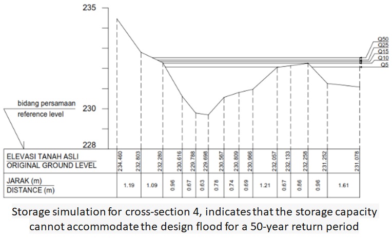
This research utilizes photogrammetry to assess flood routing dynamics in the Contok river basin, a sub-watershed with a challenging landscape characterized by steep slopes, dense vegetation, and meandering patterns. The objectives are to assess Unmanned Aerial Vehicle (UAV) mapping accuracy, evaluate the river's capacity for design flood volumes, quantify the impact of land cover changes on surface runoff, and provide insights for early warning systems and watershed conservation strategies. The study area, encompassing the Contok River Basin, a sub-watershed of the Garang Watershed, covers 7,413 km² and includes a stream length of 5,274 meters in Semarang City, Central Java, Indonesia. This research employed image processing of aerial photographs and satellite imagery. Aerial photos captured using UAV data were utilized to derive elevation data and cross-sectional profiles of the Contok River, essential for understanding channel morphology and hydraulic characteristics. Concurrently, satellite imagery was used for land cover analysis, identifying vegetation and built-up areas that influence surface runoff dynamics. Hydrological analysis was performed to quantify discharge magnitudes, simulated against river cross-sections to evaluate flood behavior under varying scenarios. Our proposed UAV mapping provides adequate accuracy for small and local areas. Furthermore, it remains reliable for flood routing analysis. We discovered that the capacity of the Contok River channel in the downstream area allows it to convey design flood discharges up to a 50-year return period, contrary to the upstream area, it overflows. Notably, the shift from vegetated to built-up and agricultural areas significantly contributes to the 10.6% increase in surface runoff. This research highlights the role of UAV-based photogrammetry in assessing and mitigating flood hazards amidst evolving land cover patterns. It also enhances the understanding of flood dynamics and thus provides insights that will serve as a reference for flood early warning systems, flood management practices, and watershed conservation.
References
Annis A, Nardi F, Petroseli A, Apollonio C, Arcangeletti E, Tauro F, Grimaldi S. 2020. UAV DEMs for Small Scale Flood Hazard Mapping. Water. https://doi.org/10.3390/w12082232
Badan Informasi Geospasial-BIG. 2014. Peraturan Kepala BIG Nomor 15 Tahun 2014 tentang Pedoman Teknis Ketelitian Peta Dasar. Jakarta: BIG. In Bahasa
Badan Nasional Penganggulangan Bencana-BNPB. 2023. Data Informasi Bencana Indonesia. Retrieved December 18, 2023, from https://dibi.bnpb.go.id/ In Bahasa
Badan Standarisasi Nasional-BSN. 2022. SNI 8840-3:2022 Sistem Peringatan Dini Bencana - Bagian 3: Banjir. Jakarta: Badan Standarisasi Nasional. In Bahasa
Daud SM, Yusof MY, Heo CC, Khoo LS, Singh MK, Mahmood MS, Nawawi H. 2022. Applications of Drone in Disaster Management: A Scooping Review. Science Justice, 62, 30-42. https://doi.org/10.1016/j.scijus.2021.12.001
Dunford R, Michel K, Gagnage M, Piégay H, Trémelo ML. 2009. Potential and Constraints of Unmanned Aerial Vehicle Technology for The Characterization of Mediterranean Riparian Forest. International Journal of Remote Sensing, 4915-4935. https://doi.org/10.1080/01431160903023025
Duo E, Trembanis AC, Dohner S, Grottoli E, Caviola P. 2018. Local-scale Post-event Assessments with GPS and UAV-based Quick-response Surveys: A Pilot Case From The Emilia-Romagna. Italy) Coast. Natural Hazard and Earth System Sciences, 18(11), 2969-2989. https://doi.org/10.5194/nhess-18-2969-2018
Feng Q, Liu J, Gong J. 2015. Urban Flood Mapping Based on Unmanned Aerial Vehicle Remote Sensing and Random Forest Classifier—A Case of Yuyao, China. Water. https://doi.org/10.3390/w7105377
Fenton JD. 2019. Flood Routing Methods. Journal of Hydrology, 570, 251-264. https://doi.org/10.1016/j.jhydrol.2018.12.073
Gibson PJ, Power CH. 2000. Introductory Remote Sensing: Digital Image Processing and Applications. New York: Routledge.
Harfan A, Yudhatama D, Bachrodin I. 2019. Pemanfaatan Metode Fotogrametri Untuk Pengukuran Garis Pantai dan Identifikasi Objek-objek Tematik dengan Menggunakan Wahana UAV. Unmanned Aerial Vehicle. Studi Kasus Pengukuran Garis Pantai di Pangkalan TNI AL Pondok Dayung. Jurnal Chart Datum, 71-84. In Bahasa
Hervouet A, Dunford R, Piégay H, Belletti B, Trémélo ML. 2011. Analysis of Post-flood Recruitment Patterns in Braided-Channel Rivers at Multiple Scales Based on an Image Series Collected by Unmanned Aerial Vehicles, Ultra-light Aerial Vehicles, and Satellites. GIScience Remote Sensing, 50-73. https://doi.org/10.2747/1548-1603.50.1.50
Hill AC. 2019. Economical Drone Mapping For Archeology: Comparion of Efficiency and Accuracy. Journal of Archeological Science: Reports, 24, 80-91. https://doi.org/10.1016/j.jasrep.2018.11.021
Ikhwan M, Ratnaningsih A, Lestari I, Ikhsani H. 2021. Aplikasi Teknologi Unmanned Aerial Vehicle. UAV) untuk Mengidentifikasi Tutupan Hutan dan Lahan di Universitas Lancang Kuning. Wahana Forestra Jurnal Kehutanan, 86-101. https://doi.org/10.20886/jphh.2020.38.1.41-53 In Bahasa
Indonesia. 2019. Undang-undang Nomor 17 Tahun 2019 tentang Sumber Daya Air. Jakarta: Kementerian Hukum dan HAM. In Bahasa
Karamuz E, Romanowicz RJ, Doroszkiewicz J. 2020. The Use of Unmanned Aerial Vehicles in Flood Hazard Assessment. Journal of Flood Risk Management. https://doi.org/10.1111/jfr3.12615
Kim SS, Kim TH, Sim JS. 2019. Applicability Assessment of UAV Mapping for Disaster Damage Investigation in Korea. The International Archives of the Photogrammetry Remote Sensing and Spatial Information Science, 209-214. https://doi.org/10.5194/isprs-archives-XLII-3-W6-209-2019
Kodoatie RJ, Sugiyanto. 2002. Banjir: Beberapa Penyebab dan Metode Pengendaliannya dalam Perspektif Lingkungan. Yogyakarta: Pustaka Pelajar. In Bahasa
Lillesand TM, Kiefer RW. 1998. Penginderaan Jauh dan Interpretasi Citra. 4 ed. Yogyakarta: Gadjah Mada University Press. In Bahasa
Mabrur AY, Agustina F. 2022. Pemetaan Orthophoto untuk Rencana Pembuatan Peta Rawan Longsor. Jurnal Ilmiah Universitas Batanghari Jambi, 408-411. https://doi.org/10.33087/jiubj.v21i2.1630 In Bahasa
Marini Y, Emiyati, Hawariyah S. 2014. Perbandingan Metode Klasifikasi Supervised Maximum Likelihood dengan Klasifikasi Berbasis Objek untuk Inventarisasi Lahan Tambak di Kabupaten Maros. Prosiding Seminar Nasional Penginderaan Jauh 2014, 505-516. In Bahasa
Marjuki B, Astutik S, Hartini KS, Wijanarko SR, Prananingtyas SR, Ridha MR, Ananda R. 2019. Pemetaan menggunakan UAV. Pusdatin Kementerian PUPR Indonesia.
Michez A, Piégay H, Lisein J, Claessens H, Lejeune P. 2016. Classification of Riparian Forest Species and Health Condition Using Multi-temporal and Hyperspatial Imagery from Unmanned Aerial System. Environmental Monitoring and Assessment. https://doi.org/10.1007/s10661-016-5282-0
Park J, Cho YK, Kim S. 2022. Deep learning-based UAV image segmentation and inpainting for generating vehicle-free orthomosaic. International Journal of Applied Earth Observation and Geoinformation. https://doi.org/10.1016/j.jag.2021.102520
Putra RS, Riani D, Silitonga SP. 2023. Pembuatan Digital Elevation Model Universitas Palangka Raya Menggunakan Drone dan GPS Geodetik. Jurnal Basement, 1, 33-40. https://doi.org/10.1016/j.basment.2023.01.004 In Bahasa
Rachmanto DH Ihsan M. 2020. Pemanfaatan Metode Fotogrametri Untuk Pemetaan Skala 1: 1000. Studi Kasus: Universitas Pendidikan Indonesia. Jurnal ENMAP, 81-86. https://doi.org/10.30630/enmap.v2i2.34
Rusnák M, Sládek J, Kidová A, Lehotský M. 2018. Template for high-resolution river landscape mapping using UAV technology. Measurement, 139-151. https://doi.org/10.1016/j.measurement.2018.02.036
Saksena S, Merwade V. 2015. Incorporating the effect of DEM resolution and accuracy for improved flood inundation mapping. Journal of Hydrology, 180-194. https://doi.org/10.1016/j.jhydrol.2015.08.021
Sidiq W, Hanafi F, Priakusuma D, Haruman W, Sumarso M, Setyowati N. 2022. Analisis Banjir Genangan di Kawasan Tembalang dan Sekitarnya. Jurnal Riptek, 137-144. https://doi.org/10.31289/riptek.v2i1.4261
Siswanto SY, Frances F. 2019. How land use/land cover changes can affect water, flooding and sedimentation in a tropical watershed: a case study using distributed modeling in the upper Citarum Watershed, Indonesia. Environmental Earth Sciences, 78(17), 1-15. https://doi.org/10.1007/s12665-019-8575-7
Suripin. 2004. Sistem Drainase Perkotaan yang Berkelanjutan. Yogyakarta: Andi Offset. In Bahasa
Sutjipto AT, Purwiyono TT, Azizi MA. 2017. Monitoring Pergerakan Massa Batuan Dengan Metode Terestris Menggunakan Total Station Dan Metode Fotogrametri Di Kaliwadas, Kebumen, Jawa Tengah. Workshop Seminar Nasional Geomekanika 4. Padang. In Bahasa
Tamminga AD, Eaton BC, Hugenholtz CH. 2015. UAS-based remote sensing of fluvial change following an extreme flood event. Earth Surface Processes and Landforms, 1464-1476. https://doi.org/10.1002/esp.3940
Triatmodjo B. 2008. Hidrologi Terapan. Cetakan Kedua ed.. Yogyakarta: Beta Offset.
Turner D, Lucieer A, De-Jong SM. 2015. Time Series Analysis of Landslide Dynamics Using an Unmanned Aerial Vehicle. UAV. Remote Sensing, 1736-1757. https://doi.org/10.3390/rs70301736
UCSB Climate Hazards Center. 2023. Climate Hazards Group InfraRed Precipitation with Station data. CHIRPS. Retrieved from https://www.chc.ucsb.edu/data/chirps last accessed on Jan 16, 2024
Uysal M, Toprak A, Polat N. 2015. DEM generation with UAV Photogrammetry and accuracy analysis in Sahitler hill. Measurement, 539-543. https://doi.org/10.1016/j.measurement.2015.02.018
Vericat D, Brasington J, Wheaton J, Cowie M. 2009. Accuracy assessment of aerial photographs acquired using lighter-than-air blimps: low-cost tools for mapping river corridors. River Research and Applications, 985-1000. https://doi.org/10.1002/rra.1243
Woodget AS, Carbonneau PE, Visser F, Maddock IP. 2014. Quantifying submerged fluvial topography using hyperspatial resolution UAS imagery and structure from motion photogrammetry. Earth Surface Processes and Landforms, 47-64. https://doi.org/10.1002/esp.3418
Young SS, Rao S, Dorey K. 2021. Monitoring The Erosion and Accretion of A Human-built Living Shoreline With Drone Technology. Environmental Challenges, 5. https://doi.org/10.1016/j.envc.2021.100252
Downloads
Published
Issue
Section
License
Copyright (c) 2024 Authors

This work is licensed under a Creative Commons Attribution 4.0 International License.